

National Identity
- Official name
- State of Eritrea
- Official name (in Tigrinya)
- ሃገረ ኤርትራ
- Official name (in Tigrinya, Romanized)
- Hagere Ertra
- Official name (in Arabic)
- دولة إريتريا
- Official name (in Arabic, Romanized)
- Dawlat Iritriyā
- Name etymology
the country name derives from the ancient Greek name Erythra Thalassa, meaning "Red Sea," the body of water that borders the country
Sources:- Eritrea at a Glance ↗ - Ministry of Information - Eritrea
- The World Factbook: Eritrea - CIA
- National emblem
- National flag
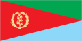
As published by the Eritrea Ministry of Information Eritrea’s flag is a rectangle divided into three triangles: a red isosceles triangle based on the hoist side, and a green upper and blue lower right triangle. A gold wreath encircling a gold olive branch is centred on the hoist side of the red triangle.
As published in EnglishAs published by the Eritrea Ministry of Information Eritrea’s national flag has four colors: red, blue, green and yellow. The red represents the blood shed in the struggle for independence. The blue represents the Red Sea and its marine resources. The Green stands for agricultural exuberance of Eritrea. The yellow represents the mineral resources of Eritrea. The olive branches on the flag have thirty leaves to represent the years of armed struggle for independence.
As published in EnglishAs published by the Eritrea Ministry of Information The olive branches, which were adapted from the 1952 Eritrean flag, represent peace.
As published in EnglishAs published by the Eritrea Ministry of Information But Eritrea had its own sovereign flag and emblem as far as back in the 1950s. Following the temporary British administration until 1952, a UN mandate federated Eritrea with Ethiopia, consenting for Eritrea to retain limited control over its local affairs. And it was then that the Eritrean flag with a blue field and a green emblem, depicting an upright olive wreath and a single branch within, was adopted.
As published in EnglishAs published by the Eritrea Ministry of Information The blue and green Eritrean flag, however, continued to be in use as the “flag of liberation” until the 1970s, until the EPLF officially came to being and proposed its own flag during the front’s First Organizational Congress in 1977.
As published in EnglishAs published by the Eritrea Ministry of Information The EPLF’s flag is dominated by a red triangle extending from the hoist to the fly (right) with complementary green and blue triangles above and below respectively. A yellow star is placed in the red triangle.
As published in EnglishAs published by the Eritrea Ministry of Information The Eritrean flag from 1952 and that of the EPLF coexisted as the flags of Eritrea until independence and the subsequent referendum in 1993. When Eritrea finally took its rightful place in the world, following its declaration as an independent and sovereign country on May 24, 1993, the new National Flag that flew in the air was in fact the EPLF’s flag with the wreath and upright olive branch symbol derived from the 1952 flag replacing the yellow star.
As published in EnglishSources:- shabait.com ↗ - the Eritrea Ministry of Information
- shabait.com ↗ - the Eritrea Ministry of Information
- shabait.com ↗ - the Eritrea Ministry of Information
- shabait.com ↗ - the Eritrea Ministry of Information
- National anthem
- Ertra, Ertra, Ertra (ኤርትራ ኤርትራ ኤርትራ)1:59
- Title (in Tigrinya)
- ኤርትራ ኤርትራ ኤርትራ
- Title (in Tigrinya, Romanized)
- Ertra, Ertra, Ertra
- Title (in English, translated)
- Eritrea, Eritrea, Eritrea
- Lyrics
Preludeኤርትራ ኤርትራ ኤርትራ፡ በዓል ደማ እናልቀሰ ተደምሲሱ፡ መስዋእታ ብሓርነት ተደቢሱ።
1መዋእል ነኺሳ ኣብ ዕላማ፡ ትእምርቲ ጽንዓት ኰይኑ ስማ፡ ኤርትራ’ዛ ሓበን ውጹዓት፡ ኣመስኪራ ሓቂ ከምትዕወት፡
Chorusኤርትራ ኤርትራ ኣብ ዓለም ጨቢጣቶ ግቡእ ክብራ።
2ናጽነት ዘምጽኦ ልዑል ኒሕ፡ ንህንጻ ንልምዓት ክንሰርሕ፡ ስልጣኔ ከነልብሳ ግርማ ሕድሪ’ሎና ግምጃ ክንስልማ፡
ኤርትራ ኤርትራSource: - Citizens
- Eritreans
- Official name:Eritrea at a Glance ↗ - Ministry of Information - Eritrea
- Official name, Citizens:The World Factbook: Eritrea - CIA
- National flag:shabait.com ↗ - the Eritrea Ministry of Information
- National flag:shabait.com ↗ - the Eritrea Ministry of Information
- National flag:shabait.com ↗ - the Eritrea Ministry of Information
- National flag:shabait.com ↗ - the Eritrea Ministry of Information
- National anthem:nationalanthems.info ↗
Geography
- Location
- Total area
- 117,600 km²
- Land area
- 101,000 km²
- Water area
- 16,600 km²
- Land borders
- 1,840 km(3 countries)
- Coastline
- 2,234 km
- Mainland
- 1,151 km
- Islands
- 1,083 km
Source:- The World Factbook: Eritrea - CIA
- Terrain
Dominated by extension of Ethiopian north-south trending highlands, descending on the east to a coastal desert plain, on the northwest to hilly terrain and on the southwest to flat-to-rolling plains - Mean elevation
- 853 m
- Highest point
- 3,018 mSoira
- Lowest point
- −75 mnear Kulul within the Danakil Depression
- Climate
Hot, dry desert strip along Red Sea coast; cooler and wetter in the central highlands (up to 61 cm of rainfall annually, heaviest June to September); semiarid in western hills and lowlands - Avg. temperature
- 26.9 °C
- Avg. daily range
- 21.7 to 32.8 °C
- Annual precipitation
- 336 mm
Temperature °CMeanDaily rangePrecipitation mmMonthly climate normals Month Avg. high, °C Mean, °C Avg. low, °C Precipitation, mm January 29.1 22.8 17.5 21 February 30.5 24 18.3 12 March 32.5 25.9 20 13 April 34.8 28.4 22.5 17 May 35.9 29.9 24.1 16 June 35.8 30.1 24.7 20 July 33.5 28.6 24.4 76 August 32.5 27.8 23.9 92 September 33.8 28.3 23.4 34 October 33.5 27.6 22.1 10 November 31.8 25.7 20.3 11 December 29.9 23.7 18.5 14 Country-wide averages over 1991–2020.
Sources:- The World Factbook: Eritrea - CIA
- Climate Change Knowledge Portal (ERA5 reanalysis) ↗ - World Bank
- Weather
- Loading
- Land use2023
- Arable5.7%Pasture56.9%Forest12.0%Other25.3%
- Arable land
- 690,000 hectares (5.7%)
- Permanent crops
- 2,000 hectares (0.0%)
- Permanent meadows & pastures
- 6,900,000 hectares (56.9%)
- Forest
- 1,453,980 hectares (12.0%)
- Other land
- 3,071,840 hectares (25.3%)
Source: - Natural hazards2026
- Drought6.2High#25/191Epidemics5.5High#77/191Coastal floods4.0Medium#90/191Earthquakes3.5Low#95/191River floods1.3Very low#146/191Tsunamis0.0Very lowTropical cyclones0.0Very low
Scores out of 10, ranks out of 191 countries.
Source:- INFORM Risk Index ↗ - European Commission Joint Research Centre
- Location, Land borders, Coastline, Terrain, Mean elevation, Highest point, Lowest point, Climate:The World Factbook: Eritrea - CIA
- Climate:Climate Change Knowledge Portal (ERA5 reanalysis) ↗ - World Bank
- Land use:FAOSTAT Land Use domain ↗ - FAO
- Natural hazards:INFORM Risk Index ↗ - European Commission Joint Research Centre
Demographics
- Population change2026
- +2.10% per year+75,666 people/yearWorld Rank40thof 237
- Birth rate
- 28.6 per 1,000 population
- Death rate
- 5.9 per 1,000 population
- Net migration rate
- −2.0 per 1,000 population
- 2026
- 19.5 yearsWorld Rank205thof 237
- Age structure2026
- 0-14 years37.1%15-64 years58.6%65 years +4.3%
- Share aged 65 and over
- 4.3%
- Share aged under 18
- 44.2%
- Total dependency ratio
- 71
- Youth dependency ratio
- 63
- Elderly dependency ratio
- 7
- Sex ratio
- 0.98 male / female
MaleAgeFemalePopulation by age group, % of total population Age Male Female 80+ 0.3% 0.4% 70-79 0.8% 1.1% 60-69 1.7% 2.2% 50-59 2.8% 3.3% 40-49 3.7% 4.0% 30-39 5.8% 5.8% 20-29 9.6% 9.6% 10-19 11.9% 11.7% 0-9 12.7% 12.5% - 2026
- 1.35 above the replacement level for Eritrea ()3.55 births per womanreplacement 2.201234World Rank37thof 237
- 1.65 daughters per woman0.65 above replacement, long-run each generation larger than the lastreplacement 1.000.511.52
- 2026
- +22.7 per 1,000 populationfor every 1,000 people, 22.7 more births than deaths a year
- 2026
- −2.0 per 1,000 population
- Urbanization2026
- 34.6% live in cities1,272,472 urban residents
- Largest urban areas2026
- Massawa, Keren, Asmara, GhindaRankUrban AreaPopulation (2026 estimate)1Massawa364,2272Keren260,0913Asmara231,3674Ghinda160,2135Barentu99,7526Teseney97,0337Nefasit72,2708Assab70,3509Dekemhare63,72410Agordat51,983
Unlike official city figures, UN urban areas cover the entire built-up area, which can include multiple cities and towns.
- Population distribution
- Density is highest in the center of the country, in and around the cities of Asmara (capital) and Keren; smaller settlements exist in the north and south.
- Ethnic groups2021
- Covers Eritrea's nine recognized ethnic groups.Tigrinya50.0%Tigre30.0%Saho4.0%Afar4.0%Kunama4.0%Bilen3.0%Hedareb/Beja2.0%Nara2.0%Rashaida1.0%
- Religions
- Eritrean Orthodox, Roman Catholic, Evangelical Lutheran, Sunni Muslim
- Languages
- Tigrinya (ትግርኛ), Arabic (العربية)
- Population, Population change, Median age, Age structure, Total fertility rate, Net reproduction rate, Natural change, Net migration rate:UN World Population Prospects ↗
- Urbanization, Largest cities:UN World Urbanization Prospects ↗
- Population distribution, Ethnic groups, Religions:The World Factbook: Eritrea - CIA
Government & Administration
- Form of state
- RepublicNo constitution is in force: the 1997 Constitution was ratified but never implemented.
- System of government
- Not statedThe 1997 Constitution was ratified but never brought into force, and no national election has been held under it. The National Assembly has not met since 2002, and the President legislates by proclamation and decree.
- System in practice
- Unified authority
- Territorial organisation
- Unitary
- Transitional arrangement
- Yes
- Official websites
- Capital
- Asmara380,568 people(2001)
- National holidays
- 15 days in 2026
- ThuJan 1New Year's Day
- WedJan 7Orthodox Christmas
- MonJan 19Epiphany
- SunMar 8Women's Day
- FriMar 20Eid al-Fitr (estimated)
- FriApr 10Good Friday
- SunApr 12Orthodox Easter
- FriMay 1International Workers' Day
- SunMay 24Independence Day
- WedMay 27Eid al-Adha (estimated)
- SatJun 20Martyrs' Day
- TueAug 25Prophet's Birthday (estimated)
- TueSep 1Revolution Day
- FriSep 11Ethiopian New Year
- SunSep 27Finding of the True Cross
Nationwide public holidays only, excluding regional, bank and government-only days.
- Time
- EATEast Africa TimeUTC+3
- Currency
- Eritrean Nakfa (ERN)
- Calling code
- +291
- Internet TLD
- .er
- ISO 3166-1 codes
- ER, ERI
- Infrastructure
- Railways306 km
- Passengers carried
- 101,357 by the country's airlines(2019)
- Aircraft departures
- 1,111 by the country's airlines(2019)
- Air freight
- 0 million tonne-km(2019)
- Aircraft registration prefix
- E3
Sources:- The World Factbook: Eritrea - CIA
- World Development Indicators ↗ - World Bank
- 2025
- 13 / 100World Rank177thof 182Confidence interval
Corruption index score by year Year Score Lower bound Upper bound 2012 25 10 40 2013 20 2 38 2014 18 5 31 2015 18 5 31 2016 18 8 28 2017 20 11 29 2018 24 10 38 2019 23 12.1 33.9 2020 21 13.5 28.5 2021 22 13.8 30.2 2022 22 14.2 29.8 2023 21 13.2 28.8 2024 13 4 22 2025 13 4.2 21.8 Source:- Corruption Perceptions Index 2025 ↗ - Transparency International, CC BY 4.0
- Form of state, System of government, System in practice, Territorial organisation, Transitional arrangement:Eritrea at a Glance ↗ - Embassy of the State of Eritrea in India
- Form of state, System of government, System in practice, Territorial organisation, Transitional arrangement:Eritrea at a Glance III ↗ - Ministry of Information of Eritrea (Shabait)
- Form of state, System of government, System in practice, Territorial organisation, Transitional arrangement:Report of the Special Rapporteur on the situation of human rights in Eritrea, A/HRC/59/24, 12 May 2025 ↗ - United Nations Human Rights Council
- National holidays:Open World Holidays Framework (vacanza/holidays) ↗
- Infrastructure:The World Factbook: Eritrea - CIA
- Infrastructure:World Development Indicators ↗ - World Bank
- Corruption Perceptions Index:Corruption Perceptions Index 2025 ↗ - Transparency International, CC BY 4.0
Economy
- Low income
- GDP (nominal)2019latest available
- $2 billion
- GDP growth (real)2019latest available
- +3.8% per year
- GDP per capita (PPP)2019latest available
- $1,821
- GDP per capita (nominal)
- $567
Source: - Inflation2019latest available
- 1.3%up 15.7 percentage points15.7pp from 2018
- Labor force2024
- 1.7 million (48% of population)World Rank132ndof 187
- Labor force participation2024
- 78.3% of people aged 15+
- Unemployment2024
- 5.9%
- Youth unemployment2024
- 10.1% ages 15 to 24
- Labor productivity2024
- $2.5 per hour worked at PPP
- Budget balance2019latest available
- 2.7% of GDP surplus
- Current account
- 13% of GDP, $257 million surplus
Source: - Debt2019
- Central government debt260.4% of GDP
- Trade2023
- China67%

- United Arab Emirates26%

- Philippines5%

- Italy1%

- Croatia1%

Source:- The World Factbook: Eritrea - CIA
- Agricultural products2024
- Raw milk of camel, Sorghum, Millet, and 6 more
- 1Raw milk of camel49×
- 2Sorghum35.8×
- 3Millet13.3×
- 4Raw milk of goats7.7×
- 5Barley7.5×
- 6Meat of cattle with the bone (fresh or chilled)6×
- 7Raw milk of cattle2.5×
- 8Wheat0.5×
- 9Maize (corn)0.3×
ProductSource:- FAOSTAT ↗ - Food and Agriculture Organization
- Gold reserves2019latest available
- NoneNo gold in official reserves
- Industries
- food processing, beverages, clothing and textiles, light manufacturing, salt, cement
- Income level, Gold reserves:World Development Indicators ↗ - World Bank
- GDP (nominal), GDP growth (real), GDP per capita (PPP), Inflation, Budget balance:IMF World Economic Outlook ↗
- Labor force, Labor force participation, Unemployment, Youth unemployment, Labor productivity:ILOSTAT ↗ - International Labour Organization
- Debt:IMF Global Debt Database ↗
- Trade, Industries:The World Factbook: Eritrea - CIA
- Agricultural products:FAOSTAT ↗ - Food and Agriculture Organization
Cost of Living
Society
- 2023
- 0.503LowWorld Rank178thof 193EritreaWorld
Human Development Index by year Year Eritrea World 2005 0.474 0.681 2006 0.473 0.688 2007 0.472 0.694 2008 0.457 0.698 2009 0.462 0.701 2010 0.465 0.707 2011 0.480 0.713 2012 0.483 0.717 2013 0.479 0.721 2014 0.497 0.726 2015 0.480 0.731 2016 0.485 0.735 2017 0.480 0.739 2018 0.490 0.741 2019 0.495 0.745 2020 0.495 0.742 2021 0.496 0.742 2022 0.499 0.752 2023 0.503 0.756 Source:- Human Development Report ↗ - United Nations Development Programme
- Mean years of schooling2023
- 5.1 years
- Expected for a child today
- 7.3 years
Source:- Human Development Report ↗ - United Nations Development Programme
- Literacy2008latest available
- 64.7% of adults
- Internet users2020
- 14.3% of the population
- Households with Internet access
- 37.6%
Source:- ITU DataHub ↗ - International Telecommunication Union
- Mobile subscriptions2020
- 1.8 million
- Fixed telephone lines
- 66,000
- Fixed broadband
- 0.2 subscriptions per 100 people
Counts subscriptions, not people.
Source:- ITU DataHub ↗ - International Telecommunication Union
- Refugees hosted2025
- 119 people
- Refugees from Eritrea abroad
- 560,146
Source:- Refugee Data Finder ↗ - UN Refugee Agency
- Inbound tourists2016latest available
- 142,000 visitor arrivals(overnight and same-day)
- Visitor spending in the country
- $48 million
- Hotel beds
- 12,337
Overnight and same-day visits are not published separately. Arrivals count trips, not people.
Source:- UN Tourism Data Dashboard ↗ - UN Tourism
- UNESCO World Heritage Sites
- 1 site1 cultural
Site Asmara: A Modernist African City Source:- The World Factbook: Eritrea - CIA
- Human Development Index, Mean years of schooling:Human Development Report ↗ - United Nations Development Programme
- Literacy:UIS Data Browser ↗ - UNESCO Institute for Statistics
- Internet users, Mobile subscriptions:ITU DataHub ↗ - International Telecommunication Union
- Refugees hosted:Refugee Data Finder ↗ - UN Refugee Agency
- Inbound tourists:UN Tourism Data Dashboard ↗ - UN Tourism
- UNESCO World Heritage Sites:The World Factbook: Eritrea - CIA
Crime & Safety
- Travel advisory (US)
- Loading
- Active humanitarian crisisAug 2026
- High6.5 out of 10International displacement, Political and economic crisisSeverity by monthSep 2024 to Aug 2026What the score is made ofImpact of the crisis7.5Conditions of people affected6.4Complexity of the crisis6.0
Data reliability as rated by INFORM: High. Last updated Aug 25, 2026.
Source:- INFORM Severity Index ↗ - European Commission Joint Research Centre
- Homicide rate2012
- 15.6 per 100,000 peopleHigh by global standards
- Crime rates
- 1 offence category
Offence Per 100,000 Count Year Homicide (victims) 15.6 474 2012 A low figure can also mean weak recording.
Source:- UNODC Data Portal ↗ - UN Office on Drugs and Crime
- Active humanitarian crisis:INFORM Severity Index ↗ - European Commission Joint Research Centre
- Homicide rate, Crime rates:UNODC Data Portal ↗ - UN Office on Drugs and Crime
Health
- Life expectancy2026
- 69.4 years
- Health expenditure2023
- 3.7% of GDP$28 per person
- Physicians2022
- 0.09 per 1,000 population
- Hospital beds2023
- 1 per 1,000 population
- Infant mortality2026
- 24.0 per 1,000 live births
- Maternal mortality2023
- 291 per 100,000 live births
- Alcohol consumption2022
- 1.3 litres of pure alcohol per adult per year
- Road traffic deaths2019
- 37.9 per 100,000 population
- Life expectancy, Infant mortality:UN World Population Prospects ↗
- Health expenditure, Physicians, Hospital beds, Road traffic deaths:World Development Indicators ↗ - World Bank
- Maternal mortality:Maternal mortality estimates ↗ - UN Maternal Mortality Estimation Inter-agency Group
- Alcohol consumption:Global Health Observatory ↗ - World Health Organization
Environment
- CO₂ emissions2024
- 0.78 Mt per yearup 1.8 percent on the previous year1.8% from 2023
- CO₂ per capita
- 0.1 t per personWorld Rank201stof 207
- Share of global CO₂
- < 0.01%
- Methane (CH₄)
- 4.53 Mt CO₂-eq
- Nitrous oxide (N₂O)
- 1.28 Mt CO₂-eq
- All greenhouse gases
- 6.58 Mt CO₂-eq
Source:- Emissions Database for Global Atmospheric Research (EDGAR) ↗ - European Commission, Joint Research Centre
- 2024
- 17.9 µg/m³ of PM2.51.3 years of life expectancy lost against the WHO guidelineMost polluted71stof 236
- WHO guideline
- 5 µg/m³
Source:- Air Quality Life Index ↗ - Energy Policy Institute at the University of Chicago
- Environmental issues
- deforestation
- desertification
- soil erosion
- overgrazing
Source:- The World Factbook: Eritrea - CIA
- International agreements
- 16 of 20 landmark treaties in forceParty to 37 multilateral environmental agreements
Treaty Standing Joined Climate Paris Agreement in force 2023 UN Framework Convention on Climate Change in force 1995 Kyoto Protocol in force 2005 Ozone layer Montreal Protocol in force 2005 Vienna Convention (Ozone Layer) in force 2005 Biodiversity Convention on Biological Diversity in force 1996 CITES in force 1995 Convention on Migratory Species (Bonn) in force 2005 Cartagena Protocol on Biosafety in force 2005 Nagoya Protocol in force 2019 Land and heritage Ramsar Convention on Wetlands not a party World Heritage Convention in force 2002 UN Convention to Combat Desertification in force 1996 Chemicals and waste Basel Convention in force 2005 Rotterdam Convention (PIC) in force 2005 Stockholm Convention (POPs) in force 2005 Minamata Convention on Mercury in force 2023 Oceans UN Convention on the Law of the Sea not a party High Seas Treaty (BBNJ) not a party MARPOL 73/78 not a party Source:- International Environmental Agreements Database ↗ - Université Laval
- CO₂ emissions:Emissions Database for Global Atmospheric Research (EDGAR) ↗ - European Commission, Joint Research Centre
- Air pollution:Air Quality Life Index ↗ - Energy Policy Institute at the University of Chicago
- Environmental issues:The World Factbook: Eritrea - CIA
- International agreements:International Environmental Agreements Database ↗ - Université Laval
Food & Water
- No access to safe drinking water2022
- 42.2% of the population
- Renewable water2022
- 7.3 billion m³ per year
- Per person
- 2,146 m³ per year
- Dependency ratio
- 62% originates outside the country
- Annual water withdrawal
- 0.6 billion m³ per year
- Withdrawn for agriculture
- 95%
- Water stress
- 11% of available freshwater withdrawn
Source:- AQUASTAT ↗ - Food and Agriculture Organization
- Obesity2024
- 4.3% of adults
- Men
- 2.6%
- Women
- 5.8%
Source:- Global Health Observatory ↗ - World Health Organization
- Underweight children2010latest available
- 39.4% of children under five
- No access to safe drinking water, Renewable water:AQUASTAT ↗ - Food and Agriculture Organization
- Obesity:Global Health Observatory ↗ - World Health Organization
- Underweight children:World Development Indicators ↗ - World Bank
Energy
- Energy consumption2024
- Per capita
- 3.19 GJ per person
- Share of world total
- < 0.01%
- Supply
- No meaningful productionproduces under 2% of what it consumes, 2024
Source:- International Energy Statistics ↗ - U.S. Energy Information Administration
- Electricity2024
- 0.5 TWh generated per year
- Generation
- 0.5 TWh per year
- Consumption
- 0.4 TWh per year
Source:- International Energy Statistics ↗ - U.S. Energy Information Administration
- Oil, gas & coal
- No domestic productionconsumes 4,919 b/d in 2024Consumption20244,919 b/d
Oil imports and exports count crude oil only.
- Energy consumption, Electricity, Oil, gas & coal:International Energy Statistics ↗ - U.S. Energy Information Administration
Defense
- Military personnel2025
- estimated 150,000–200,000active Defense ForcesEstimates vary widely.
- Military service2025
- Conscriptionall citizens 18–40, 18 months, in practice often extended indefinitely; citizens up to the age of 59 eligible for recall during mobilization
18-month conscript service obligation, which reportedly includes 4–6 months of military training and 12 months of military or other national service (military service is most common).
Source:- The World Factbook: Eritrea - CIA
- Nuclear weapons2026
- None - no nuclear arsenal
- Military personnel, Military service:The World Factbook: Eritrea - CIA
- Nuclear weapons:Status of World Nuclear Forces ↗ - Federation of American Scientists

