

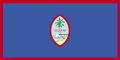
Territory under the sovereignty of the United States that is not part of any state. Congress legislates for it under the Territory Clause, and only some provisions of the U.S. Constitution apply in full. Persons born in Guam are U.S. citizens by statute.
Listed by the United Nations as a Non-Self-Governing Territory.
National Identity
- Official name
- Territory of Guam
- Official name (in English)
- Guam
- Official name (in Chamorro)
- Guåhan
- Name etymology
the native Chamorro name for the island, Guahan (meaning "we have"), was changed to Guam in the 1898 Treaty of Paris, when Spain relinquished Guam, Cuba, Puerto Rico, and the Philippines to the US
Sources:- The Organic Act of Guam and Related Federal Laws Affecting the Governmental Structure of Guam - Through June 11, 2001 ↗ - Office of Public Accountability (OPA) - Guam | Guam Public Auditor
- The World Factbook: Guam - CIA
- National emblem
- National flag
- National anthem
- The Star Spangled BannerThe national anthem of the United States.1:18
- Title
- The Star Spangled Banner
- Lyrics
- English
1Oh, say can you see by the dawn’s early light What so proudly we hailed at the twilight’s last gleaming? Whose broad stripes and bright stars thru the perilous fight, O’er the ramparts we watched were so gallantly streaming? And the rocket’s red glare, the bombs bursting in air, Gave proof thru the night that our flag was still there. Oh, say does that star-spangled banner yet wave O’er the land of the free and the home of the brave?
2On the shore, dimly seen through the mists of the deep, Where the foe’s haughty host in dread silence reposes, What is that which the breeze, o’er the towering steep, As it fitfully blows, half conceals, half discloses? Now it catches the gleam of the morning’s first beam, In full glory reflected now shines in the stream: ‘Tis the star-spangled banner! Oh long may it wave O’er the land of the free and the home of the brave.
3And where is that band who so vauntingly swore That the havoc of war and the battle’s confusion, A home and a country should leave us no more! Their blood has washed out of their foul footsteps’ pollution. No refuge could save the hireling and slave From the terror of flight and the gloom of the grave: And the star-spangled banner in triumph doth wave O’er the land of the free and the home of the brave.
4Oh! thus be it ever, when freemen shall stand Between their loved home and the war’s desolation! Blest with victory and peace, may the heav’n rescued land Praise the Power that hath made and preserved us a nation. Then conquer we must, when our cause it is just, And this be our motto: “In God is our trust.” And the star-spangled banner in triumph shall wave O’er the land of the free and the home of the brave.
Source: - Citizens
- Guamanians
- Official name:The Organic Act of Guam and Related Federal Laws Affecting the Governmental Structure of Guam - Through June 11, 2001 ↗ - Office of Public Accountability (OPA) - Guam | Guam Public Auditor
- Official name, Citizens:The World Factbook: Guam - CIA
- National anthem:nationalanthems.info ↗
Geography
- Location
- Oceania, island in the North Pacific Ocean, about three-quarters of the way from Hawaii to the Philippines
- Total area
- 544 km²
- Land area
- 544 km²
- Water area
- 0.00 km²
- Land borders
- None
- Coastline
- 125.5 km
- Terrain
Volcanic origin, surrounded by coral reefs; relatively flat coralline limestone plateau (source of most fresh water), with steep coastal cliffs and narrow coastal plains in north, low hills in center, mountains in south - Highest point
- 406 mMount Lamlam
- Lowest point
- 0 mPacific Ocean
- Climate
Tropical marine generally warm and humid, moderated by northeast trade winds; dry season (January to June), rainy season (July to December); little seasonal temperature variation - Avg. temperature
- 27.1 °C
- Avg. daily range
- 26.3 to 27.7 °C
- Annual precipitation
- 2,105 mm
Temperature °CMeanDaily rangePrecipitation mmMonthly climate normals Month Avg. high, °C Mean, °C Avg. low, °C Precipitation, mm January 27.1 26.6 26 84 February 26.8 26.3 25.7 63 March 26.9 26.5 25.9 60 April 27.4 26.9 26.2 81 May 27.9 27.3 26.6 98 June 28.2 27.5 26.6 157 July 28.2 27.3 26.3 289 August 28.1 27.3 26.2 361 September 28.1 27.2 26.3 328 October 28.1 27.3 26.3 290 November 28.1 27.4 26.6 189 December 27.7 27.2 26.4 104 Country-wide averages over 1991–2020.
Sources:- The World Factbook: Guam - CIA
- Climate Change Knowledge Portal (ERA5 reanalysis) ↗ - World Bank
- Weather
- Loading
- Land use2023
- Arable1.9%Perm. crops13.0%Pasture14.8%Forest52.4%Other18.0%
- Arable land
- 1,000 hectares (1.9%)
- Permanent crops
- 7,000 hectares (13.0%)
- Permanent meadows & pastures
- 8,000 hectares (14.8%)
- Forest
- 28,270 hectares (52.4%)
- Other land
- 9,730 hectares (18.0%)
Source:
- Location, Land borders, Coastline, Terrain, Highest point, Lowest point, Climate:The World Factbook: Guam - CIA
- Climate:Climate Change Knowledge Portal (ERA5 reanalysis) ↗ - World Bank
- Land use:FAOSTAT Land Use domain ↗ - FAO
Demographics
- Population change2026
- +0.70% per year+1,186 people/yearWorld Rank120thof 237
- Birth rate
- 16.8 per 1,000 population
- Death rate
- 7.1 per 1,000 population
- Net migration rate
- −2.8 per 1,000 population
- 2026
- 31.6 yearsWorld Rank126thof 237
- Age structure2026
- 0-14 years25.7%15-64 years60.7%65 years +13.6%
- Share aged 65 and over
- 13.6%
- Share aged under 18
- 30.3%
- Total dependency ratio
- 65
- Youth dependency ratio
- 42
- Elderly dependency ratio
- 22
- Sex ratio
- 1.02 male / female
MaleAgeFemalePopulation by age group, % of total population Age Male Female 80+ 1.1% 1.6% 70-79 2.9% 3.4% 60-69 5.0% 5.1% 50-59 5.6% 5.7% 40-49 5.4% 5.3% 30-39 6.6% 5.9% 20-29 7.0% 6.4% 10-19 8.2% 7.8% 0-9 8.8% 8.3% - 2026
- 0.58 above the replacement level for Guam ()2.68 births per womanreplacement 2.10123World Rank64thof 237
- 1.27 daughters per woman0.27 above replacement, long-run each generation larger than the lastreplacement 1.000.511.5
- 2026
- +9.6 per 1,000 populationfor every 1,000 people, 9.6 more births than deaths a year
- 2026
- −2.8 per 1,000 population
- Urbanization2026
- 94.3% live in 160,444 urban residents
- Largest places2020
- Dededo, Machanao, Apotgan, Y PapaoRankCensus-Designated PlacePopulation (2020 census)1Dededo6,8552Machanao5,8093Apotgan5,2244Y Papao5,2135Mangilao5,1456Liguan4,6537Mataguac4,6538Upper Tumon4,0819North Gayinero3,99710Astumbo3,921Source:
- U.S. Census Bureau (2020 census), via City Population by Thomas Brinkhoff ↗
- Population distribution
- No large cities exist on the island; large villages (municipalities) attract much of the population; the largest of these is Dededo.
- Ethnic groups2020
- Native Hawaiian and other Pacific Islander46.1%Asian35.5%White6.8%African descent or African-American0.9%Indigenous0.1%Other0.6%Mixed10.0%
- Native Hawaiian and other Pacific Islander
- 46.1%
- Chamorro
- 32.8%
- Chuukese
- 6.7%
- Palauan
- 1.4%
- Pohnpeian
- 1.4%
- Yapese
- 1.0%
- Other Native Hawaiian and other Pacific Islander
- 2.8%
- Asian
- 35.5%
- Filipino
- 29.1%
- Korean
- 2.2%
- Japanese
- 1.4%
- Chinese (except Taiwanese)
- 1.3%
- Other Asian
- 1.5%
Source:- The World Factbook: Guam - CIA
- Religions2020
- Christian94.2%Folk religion1.5%Buddhist1.1%Other1.6%Unaffiliated1.7%
Christians are predominantly Roman Catholic.
Source:- The World Factbook: Guam - CIA
- Languages
- English, Chamorro (Chamoru)
- Population, Population change, Median age, Age structure, Total fertility rate, Net reproduction rate, Natural change, Net migration rate:UN World Population Prospects ↗
- Urbanization:UN World Urbanization Prospects ↗
- Largest cities:U.S. Census Bureau (2020 census), via City Population by Thomas Brinkhoff ↗
- Population distribution, Ethnic groups, Religions:The World Factbook: Guam - CIA
Government & Administration
- Form of state
- RepublicShared with the United States: the President of the United States is head of state.Guam's status and three-branch government are set by the Organic Act, a statute of the United States Congress that Congress can amend; Guam has no constitution of its own (48 U.S.C. §1421a).
- System of government
- PresidentialExecutive power is vested in a Governor elected jointly with the Lieutenant Governor by majority vote, with a run-off if needed; the Legislature cannot remove the Governor, who faces only popular recall, and cannot itself be dissolved (48 U.S.C. §§1422, 1422a, 1423).Source:
- Official websites
- Capital
- Hagåtña943 people(2020)
- National holidays
- 16 days in 2026
- ThuJan 1New Year's Day
- MonJan 19Martin Luther King Jr. Day
- MonFeb 16Washington's Birthday
- MonMar 2Guam Discovery Day
- FriApr 3Good Friday
- MonMay 25Memorial Day
- FriJun 19Juneteenth National Independence Day
- FriJul 3Independence Day (observed)
- SatJul 4Independence Day
- TueJul 21Liberation Day (Guam)
- MonSep 7Labor Day
- MonNov 2All Souls' Day
- WedNov 11Veterans Day
- ThuNov 26Thanksgiving Day
- TueDec 8Lady of Camarin Day
- FriDec 25Christmas Day
Nationwide public holidays only, excluding regional, bank and government-only days.
- Time
- ChSTChamorro Standard TimeUTC+10
- Currency
- US Dollar (USD)
- Entry requirements
- Official visa and entry information
- Calling code
- +1-671
- Internet TLD
- .gu
- ISO 3166-1 codes
- GU, GUM
- Infrastructure
- Heliports
- 2
- Aircraft registration prefix
- N
Source:- The World Factbook: Guam - CIA
- Form of state, System of government:Organic Act of Guam, Act of August 1, 1950, ch. 512, 64 Stat. 384, as amended, 48 U.S.C. ch. 8A, United States Code, 2023 Edition ↗ - U.S. Government Publishing Office
- National holidays:Open World Holidays Framework (vacanza/holidays) ↗
- Infrastructure:The World Factbook: Guam - CIA
- Infrastructure:World Development Indicators ↗ - World Bank
Economy
- High income
- Labor force2024
- 77,324 (46% of population)World Rank182ndof 187
- Labor force participation2024
- 62.3% of people aged 15+
- Unemployment2024
- 5.3%
- Youth unemployment2024
- 12.9% ages 15 to 24
- Labor productivity2024
- $73.5 per hour worked at PPP
- Trade2023
- Taiwan42%

- Hong Kong12%

- Philippines11%

- Italy8%

- Australia6%

Source:- The World Factbook: Guam - CIA
- Industries
- national defense, tourism, construction, transshipment services, concrete products, printing and publishing, food processing, textiles
- Income level:World Development Indicators ↗ - World Bank
- Labor force, Labor force participation, Unemployment, Youth unemployment, Labor productivity:ILOSTAT ↗ - International Labour Organization
- Trade, Industries:The World Factbook: Guam - CIA
Cost of Living
- Average gross salary2016latest available
- $2,065 per month$1,859 (PPP)
- Average gross salary:ILOSTAT ↗ - International Labour Organization
Society
- Inbound tourists2024
- Official tourism site739,146 arrivalsdown 56% against 201956% below 2019World Rank92ndof 139
- Per resident
- 4.4 arrivals per resident
- Share of GDP
- 6.3% tourism direct GDP(2021, latest available)
Overnight arrivals by year2010 to 2024A tourist stays at least one night. Arrivals count trips, not people.
Source:- UN Tourism Data Dashboard ↗ - UN Tourism
- Inbound tourists:UN Tourism Data Dashboard ↗ - UN Tourism
Crime & Safety
- Homicide rate2019
- 4.3 per 100,000 peopleMedium by global standards
- Crime rates
- 1 offence category
Offence Per 100,000 Count Year Homicide (victims) 4.3 7 2019 A low figure can also mean weak recording.
Source:- UNODC Data Portal ↗ - UN Office on Drugs and Crime
- Prison population2022
- 423.8 per 100,000 people
- Persons held
- 700
Source:- UNODC Data Portal ↗ - UN Office on Drugs and Crime
- Homicide rate, Crime rates, Prison population:UNODC Data Portal ↗ - UN Office on Drugs and Crime
Health
- Life expectancy2026
- 77.8 years
- Infant mortality2026
- 9.4 per 1,000 live births
- Alcohol and Tobacco Spending2021
- 1.3% of household spendingWorld Rank86thof 105
- World median
- 3.1%
Source:- The World Factbook: Guam - CIA
- Life expectancy, Infant mortality:UN World Population Prospects ↗
- Alcohol and Tobacco Spending:The World Factbook: Guam - CIA
Environment
- 2024
- 0.6 µg/m³ of PM2.5Most polluted234thof 236
- WHO guideline
- 5 µg/m³
- National standard
- 9 µg/m³
Source:- Air Quality Life Index ↗ - Energy Policy Institute at the University of Chicago
- Environmental issues
- freshwater scarcity
- reef damage
- inadequate sewage treatment
- rapid proliferation of the non-native brown tree snake
Source:- The World Factbook: Guam - CIA
- Air pollution:Air Quality Life Index ↗ - Energy Policy Institute at the University of Chicago
- Environmental issues:The World Factbook: Guam - CIA
Food & Water
Energy
- Energy consumption2024
- Per capita
- 119.9 GJ per person
- Share of world total
- < 0.01%
- Supply
- Deficitproduces 2.9% of what it consumes, 2024
Source:- International Energy Statistics ↗ - U.S. Energy Information Administration
- Electricity2024
- No electricity trade1.9 TWh generated per year
- Generation
- 1.9 TWh per year
- Consumption
- 1.8 TWh per year
Source:- International Energy Statistics ↗ - U.S. Energy Information Administration
- Oil, gas & coal
- No domestic productionconsumes 22,006 b/d in 2024Consumption202422,006 b/d
Oil imports and exports count crude oil only.
- Energy consumption, Electricity, Oil, gas & coal:International Energy Statistics ↗ - U.S. Energy Information Administration